FLAMMA, 4 (2), 121-124, 2013 ISSN 2171 - 665X CC Attribution-NonCommercial-ShareAlike 3.0 License
Sustainability of land use in La Palma (Spain). Investigation of soil erosion in consideration of the fire history K. Umstädter (*), F. Haas, M. Becht Physical Geography, Catholic University of Eichstätt-Ingolstadt. Ostenstraße 18, 85072 Eichstätt, Germany *Corresponding author:
[email protected]
Keywords
Abstract
Canary Islands Geomorphology Soil erosion TLS Wildfire
The conservation of soil as a main resource plays an important role in consideration of a sustainable land use, i.e. securing the supply and satisfying the basic needs. Particular in the Mediterranean and subtropical region frequent wildfires lead to increasing soil erosion, that varies according to the land use form, amongst others. One target of the investigation is to quantify the soil erosion in post-fire sites with different land use (canary pine stands and vineyard areas) and to assess the sustainability in view of soil conservation. Thereby the driving forces are fire history, topography, precipitation and soil properties. For the quantification of the erosion rates, a 3D terrestrial Laser Scanner (Riegl, LMS Z420i) and dGPS is used.
1
studies (e.g. Krammes 1960, Soler & Sala 1992, Certini 2005) soil erosion rates are much higher immediately after fire events. The investigation focuses on two forms of land use and land cover change on La Palma: the canary pine forest and the vineyard areas. Both are very common and widespread on the island. The study sites show a different natural environment as well as a different fire history. They are characterized by a varying steepness, vegetation cover, and stages of soil development (the northern part of the island is older than the southern one, so the soils in the north are generally more developed). Both denudation processes and gully erosion processes are spread over the sites. Intense precipitations on post-fire sites can cause debris flows and extensive soil erosion, like in the year 2009 in the south of La Palma. Regarding that, erosion is not just a problem for agriculture, but for the infrastructure, transport and in the end it can come across
INTRODUCTION
The sustainability of land use in the subtropics is currently a major problem. Extreme rainfall events result in an increase of soil erosion, whichcan clearly exceed the soil reproduction rate; especially on steep slopes with frequent forest fires. In the future this problem could be intensified by further global warming, which may produce both more frequent drought periods and more frequent intense rain fall events.
2
OBJECTIVES
The main target of this study is to quantify the soil erosion rates on study sites with a different land use on the island of La Palma (Canary Islands). Thereby the fire history is considered as an important factor for the quantity of soil erosion (Neris 2012, Cerdà 2008). As reported in many 121
FLAMMA | Vol. 4 | 2 | 121-124
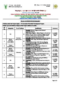
Figure 1. Gully at one of the study sites in the south of La Palma (a). The red dashed line shows the former soil surface after the fire in August 2009 and before the intensive precipitations in December 2009. The gully was scanned twice, in October 2011 and April 2012. The soil loss could be quantified with the open source software SAGA GIS. In comparison with the loss between 2011 and 2012, the soil removal between 2009 and 2011 was 15 times higher (see b; red: erosion; blue: accumulation).
122
FLAMMA | Vol. 4 | 2 | 121-124
grain size distribution was determined by means of different sieves (630, 200, 100 µm) according to Hartge & Horn (2009).
as a natural risk for humans and their goods. The utilization of the canary pine forests on La Palma is restricted to the extraction of litter for the usage in banana plantations or cattle sheds. Furthermore, for reasons of fire prevention the lower parts of the trees are cut and removed of the forest. So the forest is not just used but shaped in an anthropogenic way. The other important land use form is winegrowing, which is implemented on former forest sites.
4
Our study is still a running project. Because of that the results are preliminary. Nevertheless some very interesting conclusions can be drawn. The heavy rainfalls in December 2009 – within the period from December 20th, 2009 to December 23rd, 2009, 270 mm of precipitation fell (AEMET 2012) – which followed the intense wildfire in August 2009, caused debris flows and denudation processes in the south of the island. Seven study sites are located in this area. These precipitations originated gullies, which constitute since then the preferred runoff paths of water.
These two land use forms are located side by side, partially on the same slopes. The target of this study is to investigate the sustainability of these two land use forms and to answer the question if winegrowing represents a sustainable land use form in consideration of soil erosion compared to the original canary pine stands.
3
RESULTS AND CONCLUSIONS
METHODOLOGY
To prevent further cuttings, small dykes were installed. We scanned one of the gullies in 2011 (see Figure 1a) and could calculate the volume of the gully, i.e. the eroded material since 2009 (see Figure 1b). The former soil surface was assessed by taking the fire-blackened bark as the limit of fire influence at a tree (see the dashed red line in Figure 1a).
The current erosion rate on the study sites (canary pine and winegrowing) is measured using a 3D terrestrial Laser Scanner (Riegl LMS Z420i). On the basis of several measurements a multi-temporal analysis of the scanning data within the time frame is possible. Thus, a quantitative statement of soil erosion can be made (Haas et al. 2011, Heritage & Large 2009). With this method a remote, high speed, non-contact data acquisition using a narrow infrared laser beam is feasible. Hence the surface of the study sites is barely disturbed. The scan positions were merged together using common tiepoint reflectors. The registered data were filtered and reduced in size for a better use. Further post-processing was conducted in SAGA (System for Automated Geoscientific Analyses). The precipitation values between the two data acquisition phases were considered when analysing the data (AEMET 2012).
In the period from December 2009 to October 2011 a total of 45.4 m³ was eroded. The same site was scanned another time in May 2012. The soil removal that was detected in the period October 2011 to May 2012 was 3 m³. This small amount of erosion can be attributed to the low precipitations of the last winter period. Between October 15th, 2011 and May 1st, 2012 only 59.6 mm fell at the meteorological station in Fuencaliente-Caletas nearby. In contrast to that in January 2011 only 76.6 mm were registered at the same station. Our study shows that we are able to measure the soil erosion in canary pine stands and wine terraces accurately using terrestrial laser scanning.
All in all 20 sites were scanned, 7 winegrowing sites and 13 sites in canary pine stands. Furthermore 12 of these sites were scanned twice (5 winegrowing sites and 7 canary pine stands). The measurements took place in October 2011 and in May 2012. Two more field trips are planned in December 2012 and spring 2013.
REFERENCES Cerdà A, Doerr S H. 2008. The effect of ash and needle cover on surface runoff and erosion in the immediate post-fire period. Catena 74: 256-263. Certini G. 2005. Effects of fire on properties of forest soils: a review. Oecologia 143: 1-10. Haas F, Heckmann T, Cyffka B, Becht M. 2011. GroundBased Laserscanning – a new Method for Measuring Fluvial Erosion on Steep Slopes? - In:
Supplementary aerial images of former years are analysed relating to the appearance of linear erosion forms within the study sites. Soil samples were taken at the different sites for a better differentiation of the soil properties. The soil samples were oven-dried and the organic content was identified by means of a muffle furnace, as well as the 123
FLAMMA | Vol. 4 | 2 | 121-124
GRACE, Remote Sensing and Ground-based Methods in Multi-Scale Hydrology (Proceedings of Symposium J-H01 held during IUGG2011 in Melbourne, Australia, July 2011). IAHS Publ. 343: 163-168. Hartge K H, Horn R. 2009. Die physikalische Untersuchung von Böden. E. Schweizerbart’sche Verlagsbuchhandlung. Stuttgart. Heritage G L, Large A. R.G. 2009. Principles of Laser Scanning. Laser Scanning for the Environmental Sciences, Wiley-Blackwell, Chichester, pp.: 21-34. Höllermann P. 1995. Wald- und Buschbrände auf den westlichen Kanarischen Inseln. Akad. d. Wiss, Göttingen. Krammes JS. 1960. Erosion from Mountainside Slopes after Fire in Southern California. USDA Forest Fire Service Research Note PSW-171, Pacific Southwest Forest and Range Exp. Station, Berkeley, CA. Neris J, Tejedor M, Fuentes J, Jiménez C. 2012. Infiltration, runoff and soil loss in Andisols affected by forest fire (Canary Islands, Spain). Hydrological Processes. In press. DOI: 10.1002/hyp.9403. Soler M & Sala M. 1992. Effects of fire and of clearing in a Mediterranean Quercus ilex woodland. Catena 19: 321 - 333.
124