10 January 2015
MH370 Time to Investigate the Investigators
An unflinching, scientific critique of key search decisions, April – November, 2014
16 January 2015 Brock McEwen, M.Sc. (Mathematics) - Independent Investigator
[email protected]
Dedication This paper is for… -
the families and friends of MH370 passengers, whose agony drives me to find the truth they seek
-
my own family, who taught me the importance of telling the truth
-
my own friends, who get as upset as I do when our leaders lie
Contents Executive Summary .................................................................................................................................................1 Abbreviations and Definitions ..................................................................................................................................2 Concern #1: Analysis Underpinning March 28 Search Move ..................................................................................3 Concern #2: Analysis Underpinning April 2 Search Move .......................................................................................6 Concern #3: Claimed Authenticity of Acoustic Pings Detected Apr.5-6 ..................................................................8 Concern #4: Co-Pilot Cell Phone Connection vs. Primary Radar-Indicated Altitude ...............................................9 Concern #5: Bathymetric Survey Prioritization, April-September ..........................................................................11 Concern #6: Surface Debris Directives .................................................................................................................13 Concern #7: Western Limit of Current Search ......................................................................................................14 Conclusions ...........................................................................................................................................................17 Appendix A: Understanding the ATSB’s Original (Mar.17-27) Performance Limit..................................................18 Appendix B: Predicted Rotational Symmetry of BTO Entry/Exit Points ..................................................................19 Technical Reference ..............................................................................................................................................20 About the Author ....................................................................................................................................................20
List of Exhibits Exhibit 1:
building a performance limit …………………………………………………………………………………3
Exhibit 2:
true impact of “less available fuel” ………………………………………………………………………….4
Exhibit 3:
comparison of Mar.17 and Oct.8 performance limits……………………………………………………..5
Exhibit 4:
a fully BTO, BFO, and fuel-feasible scenario ……………………………………………………………..6
Exhibit 5:
purported primary radar track ……………………………………………………………………………….9
Exhibit 6:
cell phone bars vs. altitude ………………………………………………………………………………...10
Exhibit 7:
“Plateau” and “Plain”……………………………………….……………………………………………….11
Exhibit 8:
logical incongruity of any direct path to “the Plain” ……………………………………………………...11
Exhibit 9:
impact of logical incongruity on search area …………………………………………………………….12
Exhibit 10:
plastic drift after 8 months, starting at Oct.8 search epicentre ….……..………………………………13
Exhibit 11:
comparison of performance limit vs. time of Final Major Turn …………………………………………14
Exhibit 12:
demonstration of “missing” feasibility zone ………………………………………………………………14
Exhibit 13:
demonstrated relationship between Final Major Turn and rotation through BTO arcs ……………...15
Executive Summary On March 18, 2014 - ten days into the investigation of flight MH370 - Col. Stephen Ganyard (USMC Ret.) summarized its turning point for George Stephanopoulos on ABC’s GMA: [3:29] “The good news, here, is that we have the Australians with the NTSB now in charge of this investigation. We've seen a lot of inconsistency out of the Malaysian authorities all week; their statements haven't matched up. But now we have the real pros on the scene, and really, we are now at day one in this investigation, because we have people who know how to do this.” This paper tests the last of Col. Ganyard’s assertions: it critically examines the subsequent work of these “real pros” (referred to in this paper as “officials” or “investigators”, and meant to describe the members of the Joint Investigation Team Ganyard describes as having taken the reins from Malaysian authorities in mid-March), finds clear evidence of deception, and recommends the investigators be held to account. Specific findings: Concern #1a: No reduction in available fuel could possibly necessitate - nor even suggest - moving from the original to the Mar.28 search area. Therefore, the search did not move on Mar.28 for the reason given. Officials are challenged to explain why a false reason was given. Concern #1b: The current (Oct.8) estimated post-radar range is 7% less than its Mar.17 counterpart – officials are challenged to explain this difference. It cannot possibly be the reason given Mar.28 (“flew faster”): officials knew by mid-March that the primary radar data track forces a definite horizontal speed, with minimal vertical variation. Concern #2: The location (s21, e104) moved to on Apr.2 could not possibly be the terminus of a direct path which respects all signal data, and reaches the 7th arc before fuel exhaustion. (A direct path is forced by the current search site.) Officials are challenged to specify in full the “highest probability” path to this search site. Concern #3: Immediately upon moving the search to a place they should have known 370 lacked the fuel to reach, officials hailed as authentic acoustic pings they should have known 370’s black box could not possibly have emitted. Officials should explain how such an egregious error was permitted to misdirect the search. Concern #4: “US Officials” who confirmed to CNN Apr.14 the co-pilot’s cellphone connected with a tower (directly contradicting the primary radar track, whose speeds force an altitude at which cellphone service is nil) are challenged to identify which (primary radar, cell connect, or both) is the false information, and why they supplied it. Concern #5: The Jun-Aug search site was the terminus of a path requiring circuity near Sumatra (ruled out by current search site) and/or 400-knot speeds (nonsensical under any (auto-)pilot scenario). Officials are challenged to justify this logic, to dispel concerns these areas were surveyed for reasons unrelated to the search. Concern #6: Officials are challenged to publish the starting coordinates of drift model scenarios driving the Oct.22 claim that debris should hit Indonesian shores first, and - if those coordinates (as widely expected) conflict sharply with those of the current deep sea search zone - how such a basic error was allowed to misdirect the shore search. Concern #7: Officials should immediately rectify the performance limit misrepresentation in Fig.2 of the ATSB’s Oct.8 report, extend the high priority search zone to E84 accordingly, and explain how these errors - which bear the hallmarks of having been deliberately inserted - were allowed to misdirect the current deep-sea search. 1
Abbreviations and Definitions Agencies: JIT JACC ATSB AMSA
Joint Investigation Team Joint Agency Coordination Centre Australian Transport Safety Board Australian Maritime Safety Agency
Groups:
IG
Independent Group (of aviation, signal data, and related experts)
Reports:
A1 A2
MH370 - Definition of Underwater Search Areas (ATSB) MH370 - Flight Path Analysis Update (ATSB)
Other:
370 SIO UTC
MH370
3F1 GS
Inmarsat-3 F1 satellite key satellite responsible for all signal data Ground Station node on path of 3F1-captured signal data; located Perth, Australia
BTO
Burst Timing Offset
BFO
Burst Frequency Offset amount signal frequency was shifted by 370’s relative speed - tells us roughly how fast 370 was going relative to 3F1 - like how a train whistle changes in pitch as it goes by
Malaysian Airlines Flight 370 (a.k.a. 9M-MRO, MH370) Southern Indian Ocean Coordinated Universal Time; written as “hh:mm UTC”, or “hh:mm”
time it took signal to complete 3F1370GS3703F1 circuit - tells us how far 370 was from 3F1 at certain times - like how an echo delay tells us how far away an object is
PL Performance limit set of fuel exhaustion points for level speed BTO-constrained path th N/SnP North/South “n & PL” Northeast/Southwest intersection of nth BTO arc and PL FMT Final Major Turn hypothesized point at which 370 turned south toward the SIO nmi nautical mile(s) standard unit of distance, equal to 1.1508 miles, 1.852 kilometres (K)TAS (Knots) True Air Speed Speed of a plane relative to the air around it (in nmi / hr) (K)GS (Knots) Ground Speed Speed of a plane relative to the ground (in nmi / hr) FMT
Items reported as evidence of 370’s flight path: “Initial flight path”
Path along planned northern leg, Kuala Lumpurwaypoint IGARI
“Primary radar data” Reported radar tracking of a westward leg, IGARISumatra “published” via media “screen grab” of a slide show (see Exhibit 5) “Signal data”
Inmarsat log data indicating southward leg, SumatraSIO includes BTO and BFO components described above published May 27 as pdf (partially redacted) BTO data plot as (near-)circles or arcs on maps BFO data plot as (funnels of uncertainty around) speed/heading vectors which can rotate around (and are specific to) each arc 2
Source: IG
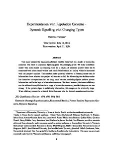
Concern #1: Analysis Underpinning March 28 Search Move After just ten days “in charge of the investigation”, the “real pros” (see interview quoted on p.1) moved the search 600nmi towards shore (wrongly, as tacitly acknowledged by their return to the original location seven months later). This section examines the rationale offered at the time for this decision, and demonstrates how the reason and the decision are incompatible. While the signal data generally – and the BTO circles particularly - were by Mar.28 the most discussed search zone determinant, range/endurance limits imposed by fuel/engine data are a key consideration as well, placing hard limits on the portions of each BTO circle 370 is physically able to reach. Fuel performance is what turns BTO circles into arcs. The best way to explain a performance limit (PL) is to describe the one the ATSB first published in A1, p.5 (reproduced and annotated at right):
N6P
6th arc
N7P
The PL is the SE border of regions S1/S2/S3. It is the set of all points of fuel exhaustion, Es, each the end of a path with the following properties: 1) begins at last known point B (e.g. last primary radar fix at 18:22 UTC) 2) a constant speed, s, is flown from B to Es 3) each BTO circle crossed at required time (e.g. 19:41 arc at 19:41)
7th arc S3
PL
S2
S6P
E410 S1
Cycling through several hypothetical speeds, s1,s2,… gives several hypothetical fuel exhaustion points, Es1,Es2,... The PL is a line running through all Es. NnP and SnP are where this PL intersects the nth BTO arc.
Exhibit 1: building a performance limit (green arc; details: Appendix A); To reach 6th BTO=dark blue arc, speed must be between 330 & 510kts
Why two intersections? Because the PL is not a circle: for relevant speeds, the PL is shaped like the point of an egg which “pokes” out over the 7th arc. This shape is a natural consequence of… 1) the fact that each path must cross each BTO-arc on cue (forces the slower paths to curl more), and 2) the basic principles of fuel endurance for jumbo jets on long flights: - too fast, and a jet plane simply burns fuel without going appreciably faster - too slow, and it drops down into dense air, increasing drag and reducing engine efficiency - “just right”, and the plane stays in the air the longest It is easy to confuse range (distance flown) with endurance (time in the air) - particularly at low speeds, where our experience with cars on flat highways leads us astray. With a car, endurance always increases as speed decreases (all else equal); for large jets on long trips, too slow = exhaust fuel sooner, because it is designed to work best at very high speeds and altitudes. To be helpful, we must significantly adjust the car analogy (e.g. the slower you go, the more skateboarders hitch a ride on your rear bumper…).
3
Accordingly, the two intersections bracket a set of hypothetical speeds which are intermediate enough to keep 370 in the air long enough to make it to 00:19. Any faster than the 500kt path ending at S7P - or any slower than the 350kt path ending at N7P - and 370 will run out of fuel prior to 00:19 (for very different reasons at each extreme). From March 17-27, the ATSB’s PL was the green line in Exhibit 2; they chose to search the S1/S2 area (intuitive, since this corresponded to paths both a) near cruising speed, and b) requiring the least contortion to satisfy all BTO constraints). However, on Mar.28, they moved the search 600nmi NE, into region S3. The reason given: reduced available fuel. The impact of a change in available fuel on the PL is a simple mathematical computation: if you remove x% of starting fuel, we must reduce the total length of each PL-generating path by y, where y is slightly less than x. Why is y less than x? Because it costs fuel to carry fuel. Removing x% of the assumed fuel has a primary impact of reducing endurance by x%, but also a secondary (and partially offsetting) effect of improving fuel efficiency due to the lighter plane. More importantly: PL-generating path lengths must ALL reduce by the SAME y%. Whatever x is, it would have generated a new PL whose path lengths were all y% shorter than those given in A1.Fig.3. (Apr/May search: off the charts)
This is neat, but how is it helpful, if we’re never given x (or y)? Because we can use this fact to build a family of possible PL’s, one of which must have been ATSB’s new PL. Exhibit 2 shows one (yellow arc: y=11%): Note that, as available fuel reduces, the “point of the egg” retreats back from the 7th arc, as the egg effectively shrinks.
S3
S2
S1
Exhibit 2: true impact of “less available fuel” on S6P* and N6P* (* ATSB used 6th arc to assess feasibility in March)
This causes S6P and N6P to move toward each other, reducing feasibility in both directions. More importantly, the special case y=11% demonstrates that NO adjustment for fuel could possibly necessitate moving from the original to the new (Mar.28Apr.2) search area. In fact, no such adjustment could possibly even suggest it: S3 is the 1st of the 3 zones rendered infeasible by removing fuel. This proves that the search did not move on March 28 for the reason given. This was explicitly admitted by ATSB Chief Commissioner Martin Dolan himself, who, in responding to the above concerns, conceded publicly (albeit with somewhat less fanfare) that the Mar.28 move occurred despite the reduction in available fuel. 4
So the fact that a false reason was given is hardly in dispute. The follow-up is obvious: why was a false reason given? Of concern: this reason was couched in statements which are technically true, yet clearly meant to mislead, e.g. the claim that less fuel was “reducing the possible distance the aircraft travelled south into the Indian Ocean”: true, but this implies a required shift NE, when the point of the egg actually retreats dramatically away from the 7th arc’s NE end. Also A1, p.6: “This increased the aircraft fuel burn and the most probable track moved north to the S3 area”: causality is strongly implied, yet unstated. Also troubling are observations by such analysts as Ben Sandilands that this move left promising surface debris unexplored. While such criticisms were levelled at decisions to leave every search site since Mar.9, they carry more weight when the official reason given for the move falls apart. Before leaving the Mar.28 announcement, it would be useful to determine just how much range was in fact removed opposite the reported reduction in available fuel. While no direct value has ever been given, an overlay of A2 Fig.3 over A1 Fig.3 suggests that roughly 7.4% of post-radar range has been removed since March (see Exhibit 3, yellow arrows). Comparability to A1 Fig.3 requires 2 adjustments to A2 Fig.3: 1) Scale to match latitude/longitude, then Exhibit 3: A1 Fig.3 (underlay)/A2 Fig.3 (overlay); A2 scaled to match grid, rotated 6° to match FMT 2) Rotate clockwise: it is provable (see p.15) that, at cruising speed, a 3 minute FMT timing delay rotates the PL roughly 1° around all BTO arcs; the 18:4018:22 FMT rotation is thus 6°. If available fuel has been the primary PL change driver (no other material reasons were given), then it drove N7P 550nmi SW – from the end of a 345kt track (per Exhibit 2) to the end of a 390kt track (per Exhibit 10, p.14, after converting altitudes to corresponding speeds), since less fuel = now impossible to stay aloft 6 hours at the ultraslow speeds. This all but rules zone S3 out. Yet S3 is where the search moved to. Finally: it is worth examining the reason given for removing fuel: that 370 was newly deemed to have “flown faster” on its westbound leg. While widely ascribed to early claims of “wild altitude swings”, this attribution is forbidden by both the timing (altitude swings were reported Mar.14) and the laws of physics: primary radarindicated speeds were a) known to investigators since mid-March (leaving no room for reinterpretation of horizontal speed), and b) fast enough to rule out any vertical speed (i.e. altitude changes; see Exhibit 5 discussion, p.9). If both vertical and horizontal speeds were fixed from mid-March onward by the primary radar track, then What did officials mean by “flew faster”? On a net basis, what has changed since Mar.17, when NTSB/ATSB gave 370 considerably more range than currently claimed? What are the implications for the southern limit of the active search?
5
Concern #2: Analysis Underpinning April 2 Search Move On Apr.2, the search was moved 750nmi further NE, placing the search epicentre 1,350nmi NE of where it had been just 6 days earlier. No reason was given in real-time for this second move. Unlike the Mar.28 move, this move placed the active search zone outside of the original performance limit documented in the previous section (and well outside the PL after correcting properly for reduced fuel). This means that their PL itself had to have moved considerably NE as well. What might extend the PL NE? a) refine the model (same inputs, but new outputs): possible, but unlikely: before spending ten days and several million dollars searching at the model’s original PL, one hopes it was well-vetted. b) add available fuel: as discussed, this helps 370 stay in the air long enough at those ultra-slow speeds. However, since fuel was in fact removed, this change takes us backwards. By several hundred nautical miles. c) relax “straight flight path” assumption: circuitous flight paths cannot be ruled out; it is entirely possible to fly, e.g., the path depicted in Exhibit 4. Any path which maintains steady speed/altitude is fuel-feasible; however, path circuity tends to raise more plausibility concerns than it allays. Any NE extension of the PL using such paths must Exhibit 4: a fully BTO, BFO, and fuel-feasible scenario. Any takers? be done strictly for the sake of academic rigour, not to search in the extension itself (no such path would be anyone’s “best estimate”). Path circuity used to be plausible: perhaps investigators had access to restricted data, which specified it. However, this is now ruled out by the current search epicentre (s38, e88), which leaves no time for loitering. Hardly the epicentre of folks who know of a secret circuity. d) rotate entry point into BTO circles: this is the only possible justification left for extending the PL to the NE and going on to search in the extended region. The initial analysis assumed that 370 turned south immediately after the last primary radar fix at 18:22, and headed directly south through the BTO circles thereafter. This can be thought of as the “clockwise bookend” for when 370 could have entered - and exited - the set of BTO circles. What is a reasonable “counter-clockwise” bookend? If all BTO/BFO data is to be respected, and extra “wiggles” in the path are disallowed, then the FMT had to have occurred by 18:40; this puts N7P at [s26, e101], per A2 Fig.3. Yet A1 Fig.4 depicts an April-era PL (SE border of S4/S5, it is vaguely implied) whose N7P is [s15, e106.5]. How was this PL constructed? It is difficult to say. The only PL-related commentary offered in A1 Appendix A is as follows: “Flight planning carried out by MAS independently showed that there was sufficient fuel onboard the aircraft to reach the positions determine by the analysis.” Either this analysis by MAS or the one behind A2 Fig.3 is wrong. “The aircraft passed close to a NW point at 1912.” A1 p.21 makes it quite clear that, in developing its PL, FMTs from as early as 18:22 to as late as 19:12 were allowed. Is this 19:12 FMT the key missing piece of the puzzle, 6
whose placement finally completes the picture of a rational argument for extending the PL far enough to accommodate the Apr.2 search move? No. In December, 2014, the 370 Search Strategy Working Group confirmed in a private communication to an independent researcher that the “NW point” was in fact: NW = [8°35.72’N, 92°35.15’E]. The good news: a rational, fuel-feasible path through all BTO arcs exists from NW to [where the search moved]. The bad news: a rational, fuel-feasible path does not exist from [last primary radar fix] to NW. Why not? Because these two points are separated by 50 minutes, but only 249nmi. If 370 maintained primary radar-indicated heading, it would have had to slow down to under 300kts (with a slight cornering tailwind, closer to 290kts TAS) in order to take that long to cover so short a distance. If this NW point is added as a constraint, it solves the fuel feasibility problem in 370’s southern leg by creating one in its western leg (this is like solving your overdraft problem with your credit card). This leaves just one possibility: that the PL extension NE was justified by a SEPARATE analysis in which 370 started from this magical starting point and time (i.e. NOT constrained by primary radar and/or signal data). While this idea has been floated by some commentators, its absurdity is self-evident; it requires us to believe that the fuel feasibility of the “highest probability” path was verified by analyzing a starkly DIFFERENT path (this is like clearing a quarterback to play based on the kicker’s physical). And that nobody noticed this. We are out of rational possibilities for moving the search to s21. Officials knew - or ought reasonably to have known - that The location moved to on April 2 could not possibly be the terminus of a path which moves directly through the BTO arcs, respects all reliable BFO readings, and yet is fast enough to prevent fuel exhaustion before the 7 th arc. Officials are challenged to specify in full the “highest probability” path on which the April 2, 2014 move to [s21, e104] was based.
7
Concern #3: Claimed Authenticity of Acoustic Pings Detected Apr.5-6 Soon after the search moved to s21 - indeed, during the very first pass of an acoustic ping detector - acoustic pings were detected. On April 11, Australian Prime Minister Tony Abbott issued the following statements: “We’re very confident the signals we’re detecting are from the black box from MH370” “We are confident that we know the position of the black box flight recorder to within some kilometres” Consensus that these statements should have been more circumspect was both strong and immediate, and the fruitless search at this “known” location disproved them convincingly. However, it is critical to note that these statements could have been – and should have been – disproved convincingly in real-time, long before months of time, energy and money were wasted. From the start - long before the search came up empty - heads were shaking. IG Member Duncan Steel’s assessment was blunt. On May 7, the official position’s absurdity was nailed by commentator William Meacham: -
detected frequency of 33.3khz was incompatible with manufacturer's specs of 37.5 +/- 1 for the FDR o expert Dr. Lee Freitag confirmed ping frequency “would not change due to deep sea conditions” dispersion of detections (9.5, 12.3 and 13.6km) incompatible with verified 2.3km FDR maximum range o the first ping set lasted 2 hours, during which the detecting ship moved 9km o the second ping set was captured by a detector located at a point 4.2km above the sea floor
Meacham concludes: “(o)ne wonders if, in the eagerness to believe and the absence of any other lead, the authorities directing the search have ignored or downplayed evidence that is clearly contrary.” This is a reasonable conclusion - in isolation. When combined with concerns raised in prior sections, however, a more ominous conclusion is difficult to avoid: On Mar.28 and Apr.2, officials moved the search a time zone closer to shore - to a place aviation experts should have told them 370 lacked the fuel to reach - and promptly hailed as authentic acoustic pings sonar experts should have told them 370’s black box could not possibly have emitted. This raises grave concerns regarding legitimacy of this portion of the search.
Some commentators concede these facts, but excuse official conduct as a “charade of necessity” – a positive (if temporary) “feel good” event to save stakeholders from the grim realities of budgetary/operational limits and/or give the appearance of purpose/industry until summer returned to the “roaring forties”. If true, this would certainly come as a relief to those of us who can imagine less noble reasons to fake a search. But regardless of motive, anyone looking to excuse this conduct should invest a brief moment viewing such a scenario from the perspective of passengers’ loved ones, whose hopes were falsely raised, and then left to rot slowly, and in the dark. More broadly: an authority has no right to lie about anything, unless it can satisfy an independent auditor that the lie is both a necessary and sufficient means of saving of human lives. Granting authorities the right to decide which lies are “white” puts us on what history shows to be a very dangerous path. Others may view the entire March/April episode as odious, but obsolete: “perhaps investigators were horrendous at the start, but they seem to have found their stride, so leave them be until they find the plane”. Again: in isolation, this might be a reasonable position to take. However, as the next sections document, the baffling conduct of search leaders continued well beyond this stage of the search - raising much broader and deeper concerns. 8
Concern #4: Co-Pilot Cell Phone Connection vs. Primary Radar-Indicated Altitude By mid-April, rumours involving AFB Diego Garcia were persistent, despite an all-out press of official and mediaaided denials. But on Apr.12, the New Straits Times published a curious story suggesting investigators knew of a cell phone connection between the co-pilot (Fariq Abdul Hamid)'s cell phone and a commercial tower. Within 48 hours, this tiny story became THE narrative worldwide – thanks primarily to its confirmation by U.S. officials in a CNN story published Apr.14. Seemingly, this discovery was the definitive evidence which not only validated the primary radar (and by extension, the signal data-indicated path into which it dove-tailed, and the search currently underway at its purported “highest probability” terminus), but also strongly implicated the pilots as prime suspects. What make this episode interesting are five facts: 1) 2) 3) 4) 5)
This story drowned out all discussion of Diego Garcia The CNN story cites unnamed sources (“U.S. officials”) whose claim was not independently corroborated The NST story cites unnamed sources (“officials”) whose claim was not independently corroborated The story’s central claim has been consistently denied by the Malaysian government, and The story’s central claim is flatly contradicted by the laws of physics
Items 1) through 4) are a matter of public record. Item 5) is proven, ironically, by the same primary radar track which was used at the time to corroborate the story: Primary radar is a misnomer; its value has been largely superseded by “secondary radar”, which provides a vastly richer array of real-time information. The only remaining advantage of primary radar seems to be that, when the transponder loses power, primary radar readings do not disappear; the only way to avoid primary radar detection is to be a) behind something bigger than you, and/or b) very far away. While position readings are accurate, altitude readings (derived by measuring a tiny [planetowerground] angle) - unless meticulously calibrated to local atmospheric conditions - are not. Malaysian primary radar was not so calibrated; and so its altitude readings were deemed hopelessly distorted by noise, and thus ignored. ...except when they were useful in deflecting attention. The “co-pilot cell phone” story was seized upon as evidence that the plane must have flown low (as the primary radar’s nominal readouts had suggested) – to avoid detection, and/or to communicate. The irony is that the component of the purported primary radar data that is reliable was telling a vastly different story. A simple plotting of the primary radar’s position vs. time (Exhibit 5) shows a Exhibit 5: Purported primary radar track of 370 (source: Lido Hotel “screen grab“) constant true airspeed of almost 500 knots. Jumbo jets are designed to fly any given speed within a fairly narrowly prescribed altitude range; going outside of this range is not only fuel-inefficient, but puts tremendous strain on the aircraft. If the primary radar indicated a constant cruising speed, then the primary radar indicated a constant cruising altitude - period. 9
Aside: wild altitude swings were quietly but officially rejected in late June – long after public misperceptions were cemented. In dismissing the primary radar-indicated altitudes, top officials claimed that a) this was why fuel reduced Mar.28 (impossible: claim was ‘flew faster’ Mar.28, not ‘altitude swings’ Mar.14), b) this rejection was brand new (impossible, per both Exhibit 5 and outside experts), c) fuel had thus now returned to their models (impossible: fuel still gone in Oct.8 models, per Exhibit 3), and d) this replaced fuel drove the search back south (impossible: more fuel counter-indicates, per Exhibit 2). All four claims are provably false: a “quadrifecta” of deception. [To be fair: d) simply reversed an earlier deception.]
Having established that the primary radar track rules out material altitude swings, we next consider the likelihood that the co-pilot’s cell phone connected.
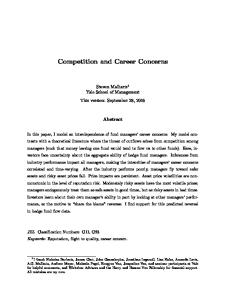
(Caution! The "bars" information in this diagram may be too generous. If so, the usable "on station" time, discussed in the next paragraph, will be reduced.)
The answer varies by era (older phones had stronger signals), but modern phones generally get no service at cruising altitude – period. One source suggests that even a high estimate of the coverage ceiling is just 32,000’ (Exhibit 6: max bars int(6 ln(altitude in 000’)/ln(2))). If 370 never dipped below 35,000’, the co-pilot’s cell phone did not connect.
Exhibit 6: 5 bars <2,000’; 4 bars <4,000’, 3 bars <8,000, 2 bars <16,000’, 1 bar <32,000’ (Source: Datasync.com) (From the source article: “Caution! The "bars" information in this diagram may be too generous.”)
Knowing that the cell phone did not connect puts the rest of the facts: 1) 2) 3) 4)
This story drowned out all discussion of Diego Garcia The CNN story cites unnamed sources (“U.S. officials”) whose claim was not independently corroborated The NST story cites unnamed sources (“officials”) whose claim was not independently corroborated The story’s central claim has been consistently denied by the Malaysian government, and
...into a decidedly different light: - Perhaps the Malaysian government was actually telling the truth. - Perhaps the unnamed sources for the original and “confirmation” stories were the same agency. - Perhaps the point of planting this story was not to illuminate, but to obfuscate – or to falsely implicate. Regardless of motive, “US Officials” quoted in the April 14 CNN article should be asked to reconcile their claim to the primary radar track, whose speed indications force an altitude at which cell phone service is nil.
10
Concern #5: Bathymetric Survey Prioritization, April-September After the debacle at s21 was finally put to sleep May 29, the underwater search was halted, and did not recommence until October. However, that did not mean officials weren’t busy. Several million dollars’ worth of bathymetric surveying was conducted, with costs split 50/50 between Australia and Malaysia; primarily in areas which are a) very shallow, and b) unlikely ever to be underwater searched. Exhibit 7 shows the first two areas selected for bathymetric survey: the “Plateau” (Wallaby Plateau, or s21) and the “Plain” (Perth-Abyssal Plain; burgundy=Jun.26-Oct.8 “high priority” zone). The Plateau was addressed in prior sections; this section considers the decision to spend three months surveying - but not searching - the Plain.
Exhibit 7: “Plateau” and “Plain” (source: Australian Transport Safety Bureau); Plain was intensively surveyed, but unlikely ever to be searched. Note depths. was survey for other reasons?
Setting up the Plain as the best-bet location of 370 was the point of the A1 report (unless one counts the attempt to retroactively justify the Plateau). How strong was its argument? Again, let’s line up the facts: 1) 2) 3) 4)
under an early FMT, a direct path to the Plain requires slow speeds (well below normal cruising speed) under an early FMT, a direct path to the Plain slowly curls (more than is explained by wind/magnetic drift) before A1 was even published, the IG had called for a search epicentre much further south soon after A1 was published, the IG pointed out the logical incongruity of a path to the Plain’s epicentre
What was the logical incongruity? The BFO data says 370 must have been flying at a fair clip relative to the satellite during its southbound leg. Neither Plain nor Plateau fit the bill (too slow) - unless entry into the Inmarsat arcs was delayed. The IG illustrated that all BFO relative speed indications – including the one at 18:40, which suggested 370 was already heading south by then – ruled out a southbound leg starting as late as was implied by the A1’s conclusion.
Exhibit 8: logical incongruity of any direct path to “the Plain” (source: IG) 11
For months, the IG sought radar disclosure to definitively rule the Plain (and its required path circuity) in or out without success. While it is possible this appalling opacity reflects security concerns - or a desire to hide an embarrassing (lack of) knowledge of 370’s track - another interpretation is possible: radar may have shown a prompt FMT and direct path - which would have ruled out the Plain. Perhaps officials were keen to survey certain regions for reasons unrelated to 370: June-August may have been more about “the Plain” than “the Plane”. What other reasons for surveying the Plain could have been influencing officials during these pivotal months? -
the weather at (what the data made obvious to analysts was a much more likely location) was dismal relatively shallow plateaus are excellent candidates for deep-see drilling/mining Malaysia was willing to pick up fully half the tab for this bathymetric surveying
Interest in deep-sea oil extraction has increased sharply in recent years. Ditto deep-sea mining. Indeed, oceanic resource extraction is one of the last frontiers in what some argue is a desperate race to grab what’s left of the planet’s untapped resources. The catch: such projects involve ever-increasing fixed costs to develop. While the correlation between ocean depth and June-August surveying was unarguably spectacular, resource prospecting is clearly a jump to a conclusion. But here again, speculation is invited by holes in the official story: A1 claims the Plain offered the best fit to signal data, but results of each of 4 IG models (Exhibit 9) casts serious doubt on this claim. The IG flunks the Plain not just on fit, but on its implausible speed: “ATSB provides no rationale for a pilot to have made a deliberate selection of this speed. If the aircraft was flying under the control of the autopilot, a human must have selected the configuration. We doubt that a pilot would select 400kts, and a lower altitude to match, regardless of the motivation.”
Exhibit 9: impact of logical incongruity on search area: IG vs. ATSB’s “Plain” (source: IG)
By Oct.8, the official team had not only decided to give considerably more weight to such “constrained autopilot dynamics”, but had also shifted the epicentre of their “data error optimization” analysis quite significantly: instead of indicating the Plain, the analysis in A2 was now suggesting a best fit 400nmi SW of where it had been in A1. Why? Officials finally decided to notice the 18:40 BFO data point. This was a relief to the IG, who for months had been screaming about this oversight; one wonders why it took until the Plain was surveyed for officials to hear. Regardless of motive, grave concerns persist that The Jun-Aug search site was the terminus of a path requiring circuity near Sumatra (ruled out by current search site) and/or 400-knot speeds (nonsensical under any (auto-)pilot scenario). Officials are challenged to justify this logic, to dispel concerns these areas were surveyed for reasons unrelated to the search. 12
Concern #6: Surface Debris Directives The utter lack of 370 surface debris recovered to date - and the overarching concerns this raises with the official story - are well-documented. This section addresses specific concerns relating to how the surface debris search has been managed. Specifically, it raises questions concerning two announcements made by search officials. Apr.28: Australian PM Tony Abbott announced the search had entered a “new phase” - by which he meant they had stopped looking for surface debris, since it was “highly unlikely” to be found, having “waterlogged and sunk”. This is an interesting stance to take on lifejackets, and the myriad of plastics, etc. which infest the water after every marine crash in which the plane breaks up on impact. Given that the working assumption was “hypoxia incapacitating all passengers and crew”, and the working location was “middle of the roaring forties”, the presence of surface debris is all but assured. PM Abbott can stop spending money whenever and wherever he pleases – perhaps scarce search resources were better spent elsewhere – but unless he knows something we don’t, he should have characterized the probability of significant surface debris somewhere in the SIO at very close to 100%, not very close to 0%. Oct.22: Despite intensive underwater efforts at three diverse and vast locations, nothing was heard regarding surface debris until Oct.22 - six months after the surface search was de-funded - when a brief directive appeared on the ATSB website. Behind Tony’s back, officials had been modeling surface debris drift. The answer: Indonesia! Specifically (it emerged in the ensuing weeks), Sumatra, Jul.8. Even more pointedly stressed: not Australia! Because debris was “far more likely to have drifted west, away from the coast of Australia”. This is a curious directive. As compiled by (IG member) Jeff Wise, for debris starting in the Oct.8 search area, drift experts and models (e.g. Exhibit 10) all peg Australia as a likely “first shore” - by as early as August. Perhaps the analysis behind this directive is stale: A1 shows drift modeling starting at now-obsolete (and/or infeasible) locations. An updated model (and one is apparently underway) may give a more intuitive result. And surely drift modeling is tricky, with small shifts in starting point producing unpredictable results. But regardless,
Indonesia
Australia
Exhibit 10: plastic drift after 8 months, starting at current search epicentre. Source: adrift.org.au
Officials should publish the starting coordinates of all scenarios driving their Oct.22 directive that Indonesians, and not Australians, should be watching their shores. If those coordinates are inconsistent with those of the current underwater search zone, officials should explain why they deliberately misdirected the volunteer search. This directive was removed from the ATSB site after only two weeks, but is archived on the JACC site. While these two announcements make perfect sense under scenarios in which officials know 370 did not crash at the current deep sea search epicentre, neither makes any sense at all under scenarios in which they think it did. 13
Concern #7: Western Limit of Current Search On Oct.8, A2 was issued, which clarified, refined, and updated, among other things, 370’s assumed PL: Fig.2: FMT = 18:28
Fig. 3: FMT = 18:40
Exhibit 11: A2 Figs. 2 and 3, depicting PL under two bookending FMT timing assumptions (source: Australian Transport Safety Bureau)
The same method used in Exhibit 3 to deduce the Mar.28 PL change can be used to validate the Oct.8 PL itself:
Exhibit 12: overlay of Figs 2 & 3; had Fig.2 been properly presented, current search zone’s western limit would extend to E84; why was it improperly presented?
Note:
- the underlying chart is simply Fig.2 (top of this page, at left) - the overlying chart id Fig.3 (top of this page, at right), rotated 4° clockwise 14
The Fig.3 overlay was rotated 4° to show where the 40,000’ performance line should have appeared in Fig.2. There is no reason whatsoever that a 40,000’ line should not appear in Fig.2, carrying beyond the 7th BTO arc by the same amount exceeded in Fig.3. The reason is simple: when moving from Fig.3 to Fig.2, only one input changes: assumed FMT (moves from 18:40 to 18:28, or 12 minutes sooner). Available fuel, speed, weight, distance, and relative path through the BTO arcs all remain the same. Why 4°? The answer is surprisingly elegant: - assume 500kts ground speed; reasonable, as this is a) speed last clocked at last primary radar fix, and b) a speed appropriate tor a 40,000’ scenario - If the FMT is delayed 12 minutes, 370 flies WNW an extra 1/5 of an hour; at 500 KGS, this represents a distance of 100nmi. - This delay magnifies into a 125nmi difference in where 370 crosses the next (19:41) BTO arc (proof: trigonometry) - This delay is 1.13% of the 19:41 circle’s circumference, or almost exactly 4° Exhibit 13: demonstrated relationship between Final Major Turn (FMT) and rotation through the BTO arcs
- A 4° rotation in the entry point into the BTO circles translates into the same 4° rotation in its exit point on the 7th arc (details: see Appendix B). The same method can be used to cross-validate all the other PL-generating flight paths: the only change from altitude to altitude is that each specifies a different speed, which in turn specifies a unique distance differential, causing the rotational degrees to decrease in proportion to the speed. When this method is applied to… a) …the two slowest paths (25,000’ and 30,000’), the lines cross-validate very well b) …the 35,000’ path, the two paths are aligned, but have different lengths (Fig.2 line is too short) c) …the 40,000’ path, we are out of luck - because no 40,000’ line appears in Fig.2 (though it should) If errors b) and c) in Fig.2 are rectified, the PL expands to the west - significantly. As Exhibit 12 demonstrates, the feasible zone grows significantly (cross-hatched pink zone), and S7P (red dots, with red arrow showing correction impact) moves west by over 3 degrees longitude, to E84 (refer to coordinates circled in black). This is highly relevant, as the western limit of the active underwater search – the point at which the search ships turn around and head back – is defined by S7P, the intersection of the 7th arc and the PL. If officials get this point wrong, they are failing to search what is, by both inside and outside expert consensus, the most likely impact point. 15
Some commentators feel that, much like an N7P extension opposite path circuity is legitimate but academic (since a circuitous path is easily ruled out for other reasons), so too might this S7P extension be legitimate but academic (because an 18:28 turn is (to them) not indicated by the BFO data). However, an 18:28 FMT has not only been ruled BFO-feasible, but is the favoured path of leading experts (e.g. Dr. Bobby Ulich). Any misrepresentation of S7P thus has profound practical consequences. More chillingly: the pair of errors (shortened 35,000’ path, missing 40,000’ path) are precisely the alterations required to ensure the 18:28 FMT did not show the PL extending west in the manner it should have. These “errors” are thus consistent with a carefully designed misdirection, meant to hide from view the fact that S7P lies significantly west of the current search’s western limit. The point of such deceit - much like the manipulations documented in prior sections - might be to preserve for future rounds of “refinement” a search extension yet further west; to engineer yet further delay in the discovery of wreckage. But regardless of motive, Officials should immediately correct and explain the misrepresentation of 370’s performance limit in the ATSB’s Oct.8 report, and extend the high priority search zone to E84 accordingly.
16
Conclusions The GMA interview (quoted on p.1) continued, exploring why Malaysian authorities had to be relieved of duty: [3:56] Stephanopoulos: “Lots of criticism of the Malaysians as you pointed out – now even the suggestion perhaps that they might have deliberately engaged in disinformation…?” Ganyard: “Boy, that's a serious charge but at this point I wouldn't doubt it. They have been so inconsistent; they have told us things that we know not to be true. Somebody needs to be held to account here. Either they're terribly incapable of running an investigation or they're hiding something, but it's one of the two.”
I wish to thank Col. Ganyard for reminding us that, when inconsistencies and untruths begin to pile up, somebody needs to be held to account.
Even in isolation, the conduct of top officials in the search for 370 since March 18, 2014 – by the folks who took over the investigation from Malaysian authorities - is nothing short of appalling: -
moving the search 600nmi NE on Mar.28, for reasons other than were claimed
-
modeling 370’s range at 7% below original estimates, with no disclosed or discernible justification
-
searching for 2 months at a location to which a fuel-feasible, signal data-fitting path is not possible
-
hailing as authentic acoustic pings sonar experts would know 370’s black box could not have emitted
-
confirming (planting?) reports the co-pilot’s cell phone pinged a tower, when primary radar rules this out
-
bathy surveying areas that are unlikely 370 search sites (but promising future resource extraction sites)
-
issuing surface debris directives drift experts should have known were irresponsible and misleading
-
misrepresenting 370’s performance limit with a subtlety which invites suspicion of intent to deceive
Taken together, a clear pattern of deliberate manipulation emerges. While highly unlikely to involve any but the most senior officials, it is hard not to spot the pattern. The evidence, quite frankly, is consistent with a search that is not being conducted in good faith. What is being hidden? Embarrassing ignorance? Guilty knowledge? It is time to find out. It is hoped that the analysis presented here will help this unacceptable situation get the attention it deserves. It is hoped that the (still-unnamed) members of the Joint Investigation Team who usurped the investigation in mid-March are held to account for having, at the very least, utterly misdirected this search.
Brock McEwen January 13, 2015
17
Appendix A: Understanding the ATSB’s Original (Mar.17-27) Performance Limit Prior to the release of A1, independent analysts were working blind with respect to 370’s performance limits, as many of the myriad of required inputs were missing, fuzzy, or otherwise suspect. However, a recent study 1 by Luis Delgado and Xavier Prats proved helpful to fill the void – and invaluable in helping understand the PLs when they did emerge. The paper measured the impact of systematically varied cruising speeds on jumbo jet fuel efficiency. The key result was Fig.6a, p.8, which plots relative change in fuel/nmi vs change in TAS, from which values were extracted and combined:
Speed delSpeed (% ) relative 2.0 1.020 -2.0 0.980 -6.0 0.940 -10.0 0.900 -14.0 0.860 -18.0 0.820 -22.0 0.780 -26.0 0.740 -30.0 0.700 -34.0 0.660
Delgado/Prats Fuel burn / nmi Endurance delFF/nmi computed (% ) relative relative 4.1 1.041 0.942 -0.4 0.996 1.024 0.6 1.006 1.058 3.2 1.032 1.077 7.6 1.076 1.081 13.8 1.138 1.072 21.7 1.217 1.054 31.4 1.314 1.028 44.4 1.444 0.989 60.1 1.601 0.946
Exhibit 12: Fuel change as function of speed change for A320 RomeParis; relative values can be calibrated to 370. Source: Technical Reference #1
The next step was to calibrate these relative endurances to 370 (a Boeing 777-200ER). A baseline speed (500 KTAS) and endurance (5.72 hours) were chosen to reflect 370’s postradar cruising performance (testing suggests results are not overly sensitive to assumed KTAS). Multiplying the above table by these values gives calibrated estimates of endurance (and range = speed x endurance) as a function of speed:
MH370 assumed (kts) 510 490 470 450 430 410 390 370 350 330
Finally, these endurance and range estimates were split into two segments (“within BTO arcs”, “beyond 7th arc”). Note the “negative excess” range at 510 and 330. When A1 was published, the split point was changed from the 7th to the 6th arc (the original basis used for adjudicating
Delgado/Prats MH370 Speed Fuel burn / nmi Endurance Range delSpeed delFF/nmi computed Entire southern leg (% ) relative (% ) relative relative (hrs) (nmi) 2.0 1.020 4.1 1.041 0.942 5.58 2,845 -2.0 0.980 -0.4 0.996 1.024 6.06 2,971 -6.0 0.940 0.6 1.006 1.058 6.26 2,943 -10.0 0.900 3.2 1.032 1.077 6.38 2,869 -14.0 0.860 7.6 1.076 1.081 6.40 2,751 -18.0 0.820 13.8 1.138 1.072 6.35 2,602 -22.0 0.780 21.7 1.217 1.054 6.24 2,433 -26.0 0.740 31.4 1.314 1.028 6.09 2,252 -30.0 0.700 44.4 1.444 0.989 5.86 2,050 -34.0 0.660 60.1 1.601 0.946 5.60 1,848
MH370 Speed Entire southern leg within BTO arcs beyond 7th arc assumed Endurance Range Endurance Range Endurance Range (kts) (hrs) (nmi) (hrs) (nmi) (hrs) (nmi) 510 5.58 2,845 5.72 2,915 -0.14 (71) 490 6.06 2,971 5.72 2,801 0.35 170 470 6.26 2,943 5.72 2,686 0.55 257 450 6.38 2,869 5.72 2,572 0.66 297 430 6.40 2,751 5.72 2,458 0.68 293 410 6.35 2,602 5.72 2,344 0.63 258 390 6.24 2,433 5.72 2,229 0.52 204 370 6.09 2,252 5.72 2,115 0.37 137 350 5.86 2,050 5.72 2,001 0.14 49 330 5.60 1,848 5.72 1,886 -0.11 (38) 18
from 18:36
feasibility), and the resulting “excess over 6th arc” distances were computed and plotted as the green lines in Exhibit 1. The fit was surprisingly good. With one exception: while both published and Delgado-derived PLs retreat relatively quickly as speed increases above normal cruising speed, the derived version exhibits an intuitive, gradual pattern, whereas the published PL appears abruptly truncated at its SW end. While it is possible the SW border was simply defined by other “limits” (those of search aircraft, e.g.), this “hidden” Mar.17 feasibility may well have foreshadowed the more clearly deliberate hiding of Oct.8 feasibility (see Concern #7). While this calibrated model was used to generate hypothetical alternative PL’s under various assumption changes (e.g. yellow line in Exhibit 2), it should be stressed that the PL-based conclusions in the body of this report do not depend on this model; for example, the PL published in A1 counter-indicates the Mar.28 move all by itself. This exercise simply offers helpful insight into how and why range and endurance respond to changing speeds.
Appendix B: Predicted Rotational Symmetry of BTO Entry/Exit Points In two of the analyses in this paper, the principle of “rotational symmetry” (if path B enters the BTO arcs xclockwise of path A’s entry point, then, all else equal, path B will exit the BTO arcs xclockwise of path A’s exit point) is invoked. This appendix shows that the above statement, while approximate, is very accurate. Below are items which might affect the rotational symmetry of path-modelling along the BTO arcs: 1. Satellite drift: Rotational symmetry requires that 3F1’s motion must be very small relative to the arc radii. In the five hours between arcs 2 & 6, 2F1 moves 50nmi. Failure to rotate this motion the same 4 degrees misplaces 3F1 (and all arcs) +/- 1.7nmi (arc 2 should be shifted 1.7nmi east, 6th arc 1.7nmi west, with lesser adjustments for those in between) – a negligible amount. 2. Earth’s shape: Rotational symmetry requires change in the earth’s radius over the modeled paths is very small relative to the arc radii. However, this too, has negligible impact in this application: a clockwise rotation of 4° shifts latitudes only 2° south - over which the earth’s radius changes only modestly. Correcting for this small shift would increase BTO arc radii by less than 0.3nmi, which misstates path length by less than 0.5nmi. 3. Wind: wind speeds and directions certainly would affect rotational symmetry - particularly for large rotations. However, winds on the night were relatively light - and the rotations being contemplated are extremely small (4-6°), so here again, impacts should be negligible. 4. Drag due to FMT severity: Range and endurance are improved by minimizing frequency and severity of turns. The later the hypothesized FMT, the more pronounced the required turn (in order to return to the next BTO arc). Here again, however, the impact is negligible: only a single turn is ever involved, and the required heading changes vary only modestly (roughly 15°). As a final point: while items 1 and 2 force an exit angle (negligibly, for our application) less than entry angle, items 3 and 4 cause exit angle to (negligibly, in our application) exceed entry angle. The offsetting nature of these items further reduces the risk of net approximation error in the application of this principle. 19
Technical Reference 1. Fuel consumption assessment for speed variation concepts during the cruise phase (Delgado/Prats); - presented to Conference on Air Traffic Management Economics, Belgrade, 2009
About the Author Brock McEwen, M.Sc. (Mathematics) is an experienced, professional analyst who empathizes with MH370 passengers’ families, perceives their need for the truth, and has dedicated his meagre talents to the pursuit of its discovery. He wishes to express his sincere gratitude to all members of the Independent Group in general for their dedicated efforts in separate but similar pursuit – and to Duncan Steel, Jeff Wise, Victor Iannello, Mike Exner, and (“honourary” IG member) Dr. Bobby Ulich in particular, for their frequent, patient, and vital assistance. Brock lives in Winnipeg, Manitoba, with his wife and two daughters, whom he cherishes with all his heart.
20