2010 Census Tracts within Brooklyn Community District 4 123 CD Community 2010 Census Tract District Boundary
Borough Boundary
°
Park
Miles 0.45
0
Note: Census tracts and community district boundaries are not coterminous. Some census tracts span multiple community districts or park areas. For census tract data visit Census FactFinder at maps.nyc.gov/census.
Source: MapPLUTO™ V.16.2, BYTES of the Big Apple. Created: August 2017.
2010 Census Tracts within Brooklyn Community District 4 - GitHub
Note: Census tracts and community district boundaries are not coterminous. Some census tracts span multiple community districts or park areas. For census tract data visit Census FactFinder at maps.nyc.gov/census. Community. District Boundary. 2010 Census Tract. Park. 123. CD. Borough. Boundary.
Note: Census tracts and community district boundaries are not coterminous. Some census tracts span multiple community districts or park areas. For census tract data visit Census FactFinder at maps.nyc.gov/census. Community. District Boundary. 2010 Ce
Note: Census tracts and community district boundaries are not coterminous. Some census tracts span multiple community districts or park areas. For census tract data visit Census FactFinder at maps.nyc.gov/census. Community. District Boundary. 2010 Ce
Note: Census tracts and community district boundaries are not coterminous. Some census tracts span multiple community districts or park areas. For census tract data visit Census FactFinder at maps.nyc.gov/census. Community. District Boundary. 2010 Ce
Note: Census tracts and community district boundaries are not coterminous. Some census tracts span multiple community districts or park areas. For census tract data visit Census FactFinder at maps.nyc.gov/census. Community. District Boundary. 2010 Ce
Note: Census tracts and community district boundaries are not coterminous. Some census tracts span multiple community districts or park areas. For census tract data visit Census FactFinder at maps.nyc.gov/census. Community. District Boundary. 2010 Ce
Note: Census tracts and community district boundaries are not coterminous. Some census tracts span multiple community districts or park areas. For census tract data visit Census FactFinder at maps.nyc.gov/census. Community. District Boundary. 2010 Ce
Created: August 2017. 0. 0.4. Miles. °. Community District. Boundary. 2010 Census Tract. Park. Note: Census tracts and community district boundaries are not coterminous. Some census tracts span multiple community districts or park areas. For census
Note: Census tracts and community district boundaries are not coterminous. Some census tracts span multiple community districts or park areas. For census tract data visit Census FactFinder at maps.nyc.gov/census. Community. District Boundary. 2010 Ce
Note: Census tracts and community district boundaries are not coterminous. Some census tracts span multiple community districts or park areas. For census tract data visit Census FactFinder at maps.nyc.gov/census. Community. District Boundary. 2010 Ce
30%. NYC. 23%. Brooklyn CD 4. LIMITED ENGLISH PROFICIENCY4 of residents 5 years or older have limited · English proficiency. Brooklyn. 21%. 25%. NYC. 21%. Brooklyn CD 4 of residents have incomes below the NYCgov poverty threshold. See the federal pov
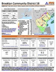
Affordable housing. 2. Cultural facilities & programs. 3. Unemployment. To learn more, please read Brooklyn CD 5's · Statements of Community District Needs · and Community Board Budget Requests · for Fiscal Year 2018. A Snapshot of Key Community Indi
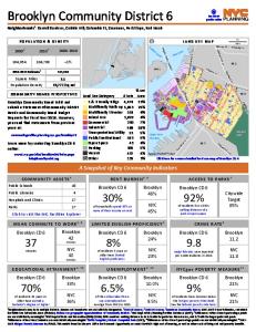
Neighborhoods1: Carroll Gardens, Cobble Hill, Columbia St, Gowanus, Park Slope, Red Hook. Brooklyn Community Board 6 did not submit a Statement of Community District. Needs and Community Board Budget. Requests for Fiscal Year 2018. However, you cand
Open Space. Parking. Vacant. Other. 3,563. 1,427. 180. 391. 253. 56. 45. 117. 67. 240. 455. 48. Kings Hwy. BeltPkw y. Bay Pkw y. O ce an. A v. O ce a n. P kw y. BK 11. BK 15. Brooklyn Community District 13. Neighborhoods1: Brighton Beach, Coney Islan
12%. NYC. 23%. Brooklyn CD 9. LIMITED ENGLISH PROFICIENCY4 of residents 5 years or older have limited · English proficiency. Brooklyn. 21%. 23%. NYC. 21%. Brooklyn CD 9 of residents have incomes below the NYCgov poverty threshold. See the federal pov
Public/Institutional. Open Space. Parking. Vacant. Other. 7,878. 1,242. 523. 1,167. 385. 18. 71. 240. 11. 81. 127. 13. Flatbush. Av. 65 St. O ce an. A v. N o stra n d. A v ... Ocean Parkway, Prospect Park South. Top 3 pressing issues identified by. B
This metric from the Mayor's Office for Economic Opportunity accounts for NYC's high cost of housing, as well as other costs of living and anti-poverty benefits. Land Use Category. % Lot. Area. # Lots. Click here for a more detailed land use map of B
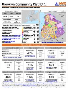
BK 13. BK 15. Brooklyn Community District 11. Neighborhoods1: Bath Beach, Bensonhurst, Gravesend, Mapleton. Top 3 pressing issues identified by. Brooklyn Community Board 11 in 2017: LAND USE MAP. 172,129. 181,981. +6%. POPULATION & DENSITY. 20002. 20
for Public Use Microdata Areas (PUMAs). PUMAs are geographic approximations of community districts. 5NYC Dept of City Planning Facilites Database (2017); 6 Differences of less than 3 percentage points are not statistically meaningful. 7NYC Dept of Pa
for Public Use Microdata Areas (PUMAs). PUMAs are geographic approximations of community districts. 5NYC Dept of City Planning Facilites Database (2017); 6 Differences of less than 3 percentage points are not statistically meaningful. 7NYC Dept of Pa